Estimated reading time: 12 minutes
Photogrammetry is transforming digital documentation across multiple industries and learning photogrammetry might help advance your skillset in your field. Today, the capacity to measure small and large datasets with millimetric precision is paving the way for increased accuracy and continuity in our record keeping. As the field of digital documentation is in its nascent stages, new applications of photogrammetry are still being found. As a leader in the field of photogrammetry training and surveying, AccuPixel finds photogrammetry can be of particular use to those working in Heritage management, Defense, and Industry. If you want future ready technical skills, keep reading to find out more about why you should learn photogrammetry and where to find reputable photogrammetry courses.

Why Should You Learn Photogrammetry?
1. Capture Measurable 3D Data
Photogrammetry takes a structured set of images and builds an accurate 3D model from the captured images. By taking a series of photographs around an object or site, you can use software (3DZephyr and Metashape) to create a 3D model from your collected photographs. Then, you can then measure real distances directly inside that model, thus improving your capacity to study and analyze a site remotely.
With photogrammetry, there is no guessing about scale so long as you control scaling properly during capture. Additionally, you can also calculate areas and volumes without going back to the site. At that point, you are no longer just taking photographs. You are creating a usable record that supports documentation, reporting, and future planning.
2. Improve Site Monitoring Workflows
Effective site monitoring demands methodological consistency and controlled acquisition. Following the steps of a recording system ensures results are repeatable. In practice, photogrammetry provides a structured framework and methodology for repeatable surveys allowing the documentation of changes over time. When one’s learning of photogrammetry is applied correctly, you can revisit and resurvey a site using the same capture parameters and control strategy. In doing so, you create new datasets with spatial accuracy allowing an analyst to identify changes to a site.
Consequently, the ongoing collection of site specific datasets enables changes such as erosion to become measurable. Likewise, as seen in the case of Thistlegorm, structural deformation becomes quantifiable rather than merely observable.
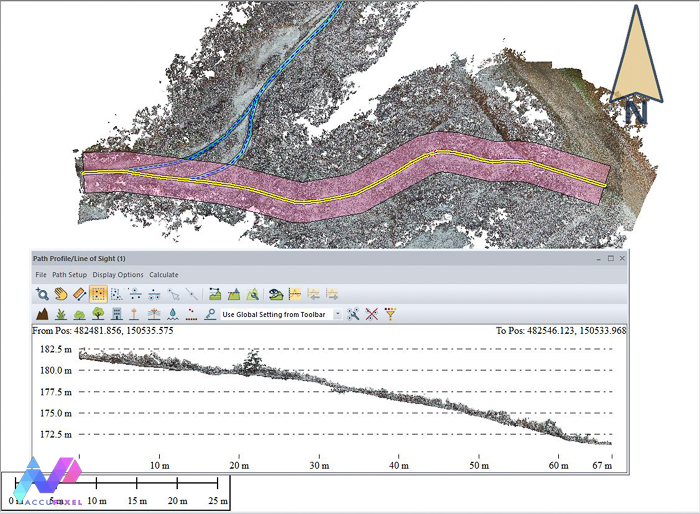
For coastal heritage, photogrammetry enables clear assessment of shoreline retreat.
Similarly, for archaeological sites, it allows deterioration to be recorded before irreversible loss occurs. In industrial contexts, photogrammetric recording supports the early identification of budding risks.
Ultimately, learning photogrammetry allows one to transcend isolated imagery and establish a defensible, referable, and chronological record. In turn, each survey contributes to a cumulative and measurable understanding of change.
3. Learn Photogrammetry and Build In-House Capability
Organisations that rely on external consultants often sacrifice long term efficiency and data control. A lot of the time, a company or organization can benefit from having an internal team member or members with a working knowledge of photogrammetry. When a business trains their teammates with a certifiable photogrammetry courses, they retain ownership of both workflow and output and minimize external factors.
In practice, this means sensitive data remains within the institution. It also means projects move forward without waiting on third party schedules and deadlines. Moreover, in house expertise strengthens technical resilience and capacity. Teams can adapt capture strategies, refine accuracy controls, and respond to evolving project demands. All of this without having to consult with anyone outside of the institution and improving in house operations.
Over time, structured photogrammetry training reduces recurring outsourcing costs.
Most importantly, it builds institutional knowledge that expands with each project completed.
4. Reduce Field Time and Increase Efficiency
One thing about fieldwork, fieldwork is expensive. It consumes personnel hours, travel budgets, carbon emissions, and environmental exposure. Photogrammetry allows you to capture complex environments in a timely and structured session. With disciplined image acquisition, you record far more detail than traditional notes or sketches.
After leaving the field and you find yourself back in the office, you can reference your datasets to extract measurements, sections, and scaled outputs. You do not need to revisit the site to confirm a dimension or depend on partial field sketches to answer new questions.
This shift is especially significant in high constraint or difficult to access environments. Underwater teams face limited bottom time. Industrial inspections operate within restricted access windows. Remote heritage sites require logistical coordination.
By consolidating documentation into one comprehensive capture event, you reduce repeat mobilization, streamline reporting, and minimize disruption to sensitive environments. Efficiency, in this context, is not about rushing, it is about capturing once and extracting value repeatedly and remotely.

Heritage documentation requires accuracy, restraint, and clarity. Heritage managers often work with sites and artifacts that cannot tolerate repeated handling. Photogrammetry allows you to record form, surface condition, and spatial context in one controlled process. One can capture the geometry of a structure without physically altering it, allowing the documentation of fragile material without increasing risk.
5. Support Heritage Documentation
In archaeological excavations, learning photogrammetry can help preserve stratigraphic relationships or identify ancient footprints, in a precise digital record. With standing architecture, you document condition thoroughly before any intervention begins. For museum collections, you can generate detailed models without relying on invasive or costly scanning equipment.
Importantly, the resulting models support more than visual interpretation.
Photogrammetry models allow curators, conservators, and researchers to examine features remotely and the sharable nature of digital data increases the capacity for peer-to-peer collaboration.
In heritage work, documentation is often the final safeguard. As seen in recent high-profile robberies, artifacts, relics, and other historic valuables are not immune to loss simply because they are housed at the Louvre. While glitzy heists are a rare occurrence, they do happen. Photogrammetry strengthens that safeguard by producing a digital record that is both precise and enduring. Even when an item has been lost, or stole, a digital record can still be referenced or seen.
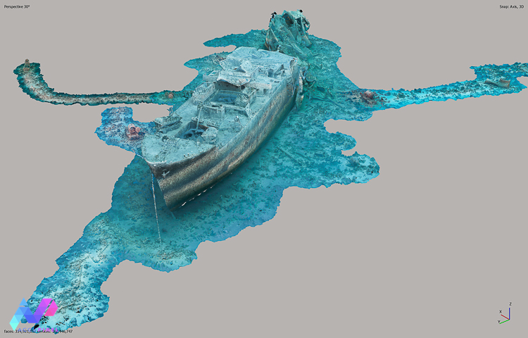
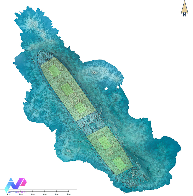
6. Enhance Underwater Recordings
As seen in the case of documenting The Thistlegorm, underwater recording demands structure and discipline. Operating in an inhospitable environment adds urgency as well as the need for planned dives to ensure success. Divers operate within strict time limits and variable visibility, meaning traditional methods rarely capture the full complexity of a wreck site. Additionally, learning photogrammetry can reduce the need for repeated disturbances to the site.
Photogrammetry training and practice fits within the scope of underwater limitations, with discipline and strict planning, photogrammetry can offer an inclusive survey. A carefully planned image sequence preserves hull structure, cargo remains, and site formation detail all within a single dive series. This method of digital documentation records spatial relationships which might otherwise be impossible to accurately sketch underwater. By leveraging digital recording methods, photogrammetric data aids heritage managers to analyze corrosion, collapse, and impact patterns with measurable reference.
In addition, utilizing photogrammetry to create a model allows researchers to navigate and digest a site, or share the data with their peers, long after returning to the surface. Underwater heritage deteriorates continuously, the underwater world is environmentally unkind towards preservation. A structured photogrammetry workflow ensures that what exists today is preserved digitally for tomorrow.
7. Reverse Engineering and 3D Printing
Today, if you are a vintage motorcycle or car enthusiast, you might have come upon the issue of part scarcity. While you can certainly hope to find a replacement crankcase cover for your classic Yamaha TY250, the reality of finding one in a junkyard is slim. However, as seen in Simon’s case study, photogrammetry can assist in creating replacement parts, especially for classic cars or hard to find parts.
So, how can learning photogrammetry or taking a certified photogrammetry course help in reverse engineering? Using a handheld scanner, reverse engineering software, CAD software and a 3D printer, Simon was successfully able to reverse engineer a replacement for a discontinued part. After installation, the Classic Yamaha was back on the road and in a much better running condition. Furthermore, the original part does not even need to be in pristine condition to be of use in the process of reverse engineering.
8. Integrate With GIS and CAD
Photogrammetry does not exist in isolation. Its real strength emerges when you integrate outputs into broader spatial workflows. Scaled orthomosaics import directly into GIS platforms for mapping and spatial analysis. Surface models support terrain assessment and elevation studies. Point clouds transition into CAD environments for drafting and engineering review.
This interoperability enables teams to move from documentation to evidence based decision making. Photogrammetrists can extract sections, generate contours, and validate alignments within established design software. In doing so, you reference real geometry rather than approximated drawings.
For survey professionals, certified photogrammetry training ensures continuity between field capture and final deliverables. Training can help users better understand and workflow efficiency, data storage methods, prevent data loss, and improve file transfers between peers. Exemplefied by engineers and planners, photogrammetry grounds design choices in measured reality. Photogrammetry becomes most powerful when it expands upon the systems professionals already use. Integration with GIS programs can transform a 3D model from a visual asset into a functional tool.
9. Future Proof Your Skillset by Learning Photogrammetry
Digital documentation standards continue to advance across heritage, survey, defense, and industry. Professionals who fail to recognize the goriwng importance of leveraging technology in their tasks risk the obsoletion of their skill sets. When you learn photogrammetry, you align your skillset with current documentation expectations. The capacity to practice photogrammetry develops one’s ability to produce measurable 3D outputs rather than static and outdated imagery.
Increasingly, funding bodies and project leads expect structured digital deliverables.
They require datasets that support analysis, replication, and long term monitoring. Moreover, photogrammetry training builds transferable technical competence which can be applied in numerous fields and applications.
By strengthening your understanding of spatial data, accuracy control, and workflow design, these capabilities position you as a contributor rather than an observer of digital change. In competitive fields, that distinction can determine who leads projects and who follows them.
10. Turn Surveys Into Long Term Assets
Most surveys capture a moment and then sit in a report archive, often physically inaccessible to reference unless you have direct access to the archives. Photogrammetry creates something fundamentally different. Photogrammetry data collection is digital by nature, meaning data and information can be shared with ease and without the necessity of physical proximity.
When you learn photogrammetry, you are not just documenting a site, you are building a dataset that can be revisited, interrogated, and reinterpreted. A properly captured model preserves geometry, surface condition, and spatial relationships in one record. That record does not expire when the project ends. Years later, you can return to the same model to extract new measurements. You can compare it against future surveys to quantify change. You can also validate claims without disturbing the site again.
For heritage managers, learning photogrammetry extends the analytical life of every field season. Whereas, for engineers and survey teams, it reduces the need for redundant site visits. However, for researchers, photogrammetry training opens the door to questions that did not exist at the time of capture.
In this sense, photogrammetry shifts documentation from a cost to an investment.
Each survey becomes a durable digital asset that continues to generate insight long after the fieldwork’s conclusion.
Who offers Certified Photogrammetry Training?
Are you wondering where you can take a photogrammetry course? At AccuPixel, we understand the importance of accessible, affordable, and reputable education. All of our courses come with a certificate of completion and feature an endorsement from either Agisoft (Metashape) or 3DFlow (3D Zephyr).
Whether you are looking to start your first steps in your photogrammetry education or you are looking to perfect an advanced skillset, we offer photogrammetry training for all levels. Learning photogrammetry can sound a bit intimidating at at first, but with well-structured courses designed to allow you to learn at your own pace, you will be making beautiful and precise 3D models by the end of your first course.
With our team ready to answer your questions via “ask a question” communications, you will find that certified photogrammetry training and photogrammetry course with AccuPixel is not just about making models, it is about connecting with experts in the field who can help you to master the digital tools you need to succeed in your field. Contact us today to start on your Photogrammetry Course.