The Military Heritage of Chesil’s Dragons’ Teeth
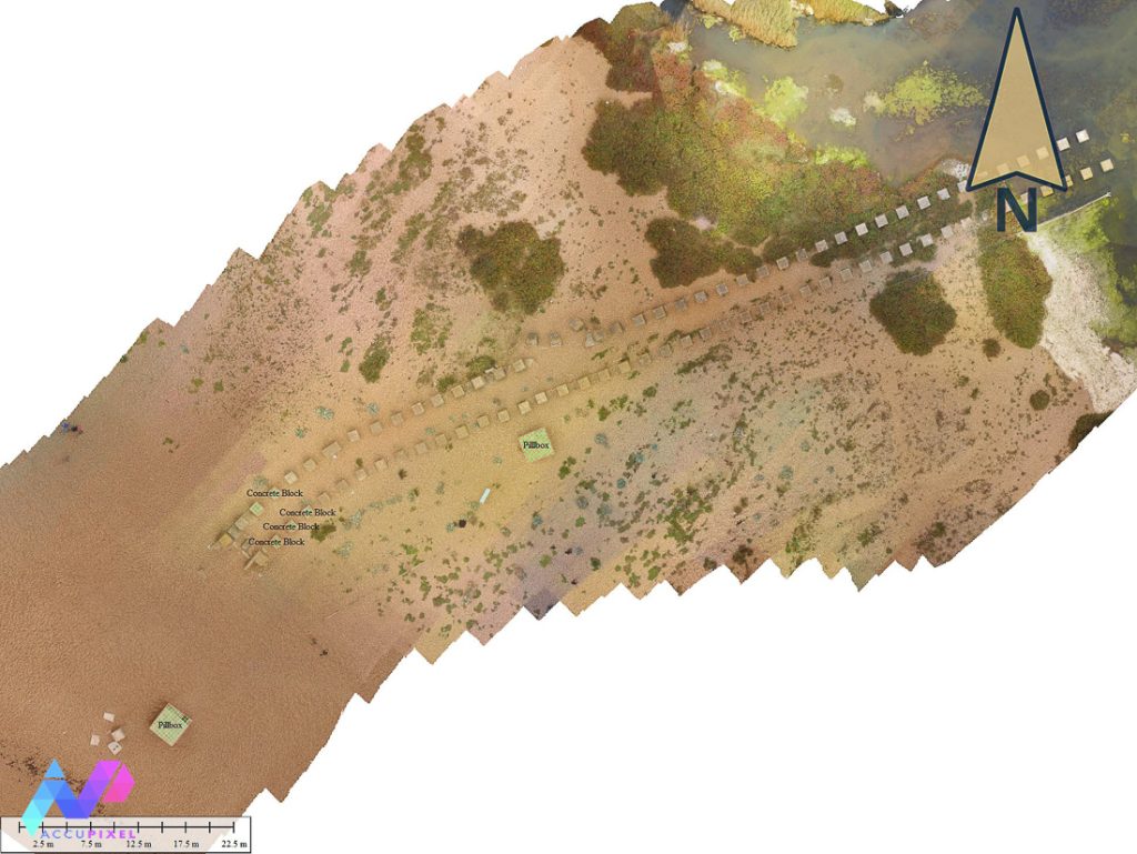
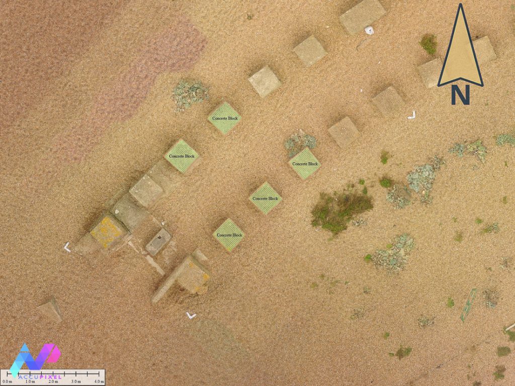
Surveying dynamic and stable environments can be a perplexing task for a photogrammetrist. The military heritage of Dorset beach offers the chance to explore how to survey a site with varying terrains and conditions. Historically, Chesil served as the training and preparation grounds for the then pending invasion of Normandy. Located in the Southeastern coast of the the UK, the beach Chesil bears the relics of the Second Great War. Two long lines of sparsely spaced concrete barriers loom across pebble laden beach. Nicknamed “Chesil’s Dragon Teeth” due to their barrier rows resemblance, the site is a silent reminder of wartime efforts. The brutish rows of concrete blocks can be seen today. These anti-tank barriers, a deterrence for a German naval invasion, extend from the water’s edge over the beach and down to the Fleet, a natural barrier of water.
Capturing the Details: Dynamic and Stable Environments
In October 2024, Simon and Alicia took the opportunity to perform a small photogrammetry survey of a singular WWII pillbox on the beach of Dorset. While the initial survey was limited to the pillbox (depicted below), to map the stretching rows of concrete barricades would require a secondary survey. The site presented an interesting exercise: surveying a dynamic and stable Environment. Seeing as the grassy terrain, 122 m from the shore, is a stable (unchanging) environment, we can scan this environmental section with more ease. However, the shore’s rocky environment shifts with each tide—meaning a timely collection of data is a priority. Seen in our Hastings Fossil blog, the nature of the sea creates its own challenge’s with photogrammetry. What makes the military heritage site of Dorset unique in photogrammetry is the incorporation of both a stable and dynamic environment into one singular output.

Capturing the Details: Field Techniques and Drones
Thankfully, the initial pillbox survey merely required a mile long hike across shifting pebbles. To properly scan the greater site required a drone. Furthermore, a permit is a necessity to use a drone in a site of specific scientific interest (SSSI) which prevented our first drone attempt. While one might believe the bureaucracy hinderance might be a mere bit of paperwork, there are good reasons why flying a drone poses a risk to nesting and migratory birds.
Managing field surveying with Wildlife
The Fleet is a shallow lagoon of mixed fresh, brackish and saltwater, and has extensive reed beds. All precious wildlife habitat. Undoubtedly, a small delay for the sake of wildlife is a worthy cause. Upon approval by Natural England, Simon was ready to take to the air himself and had a short 30 day window for the flight, timing the survey to happen before migration gets underway. Like the dinosaur beach survey, rain and wind dictated patience; but, eventually a weather window opened.
The Role of Photogrammetry in Coastal Military Surveys
In the past, traditional documentation methods could include photography, literature, and drawings. While these methods are still in use today, photogrammetry affords a method with striking precision. A digital survey of cultural heritage allows for the information of the site to be readily accessible. Information available to people and researchers all over the world. This data can be of use in comparative studies, site monitoring, and increasing the public’s knowledge of cultural heritage sites.
Whereas the public knows about the grander and more photographed markers of Second World War, such as shipwrecks. However, the barriers of Chesil beach contain the history of a country militarizing and fortifying with haste. Beyond the mapping of a dynamic and stable environment, the site itself is of historical interest. As military history is a popular topic, examining defense methods, such as anti-take barriers, can contextualize the past.
Our interest in photogrammetry leads us to ask a few questions about Chesil’s Dragon Teeth:
- What does their placement show about defensive strategy?
- Can 3D models reveal damage, erosion, or later alterations?
- How effective were these structures in their intended roles?
- How does spatial data compare with archival defense plans?
- Can reconstructions show the human effort behind the build
- How can digital access increase public engagement with lesser-known sites?
Insights from Surveying a Shifting Landscape
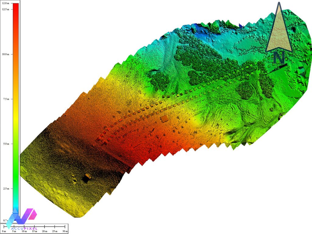
The seaward facing edge of the beach is a dynamic and shifting landscape. After one storm the beach lost around 10m of shingle, exposing a previously hidden wreck site found by Grahame Knott during a sonar survey. The shifting nature of this section of the beach is highlighted by the movement recorded in the southernmost pillbox.
Static Shingle
Perhaps the biggest surprise was how static the top and rear slope of the beach is. From the DEM there are curving and linear parallel tracks and these have been attributed to vehicles that were used to transport and install a new fence along the eastern side of the dragons teeth. This fence was installed several years ago yet the marks persist even after several winter’s worth of storms.
Conclusion on Surveying Dynamic and Stable Environments
As a result of Simon’s efforts, we now have a complete digital survey of Chesil’s military heritage, Dragon’s Teeth. Following preliminary scan of a pill box on the beach. Considering the varying environments within the site, a terrestrial survey seems implausible. Simon decides to use a drone to capture the surveying dynamic and stable environments of the shore and land. As proven again, the drone operates with reliable efficiency as long as weather, batteries, and bureaucracy cooperate. The end result allows for the establishment of a digital baseline of the site. From here out, we can monitor changes to the site accompanying future surveys.
While the preservation of cultural heritage, in this case military heritage, is an ongoing and interdisciplinary effort, we continue to find strong evidence to necessitate the use of photogrammetry. A site such as Dragon’s Teeth is often unknown by the general public. By creating (and sharing) a digital record we hope to increase public awareness of Chesil’s military heritage. Each scan adds more to the collective memory of the past and we hope to be able to ensure a site’s availability continues into the digital future.
If you’re taking on a photogrammetry project, take a moment to read how to choose your best software.