Skip to content
AccuPixel Ltd
AccuPixel Ltd
Forensic Photogrammetry Training, Products and Services
  • Home
  • What is Photogrammetry?
  • Blog
  • Photogrammetry Training
  • Webinars
  • About Us
  • Contact Us
  • Shop
  • My Account
  • £0.00 0 items

Tag: drone

At Risk Cultural Heritage

January 10, 2023 Simon Brown 2 Comments

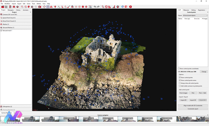
Use of drone and 3DF Zephyr to reconstruct 3D model of Sandsfoot Castle, an at-risk heritage site

Continue Reading →

Posted in: 3DF Zephyr, analysis, consultancy work, cultural heritage, digital preservation, drone, GIS, Global Mapper, photogrammetry Filed under: 3DF Zephyr, digital preservation, drone, photogrammetry

Cost Effective Results: GoPro & Mavic Drone Photogrammetry

October 28, 2021 Simon Brown

A look at using cost effective GoPro and Mavic Mini drone cameras to gather source images for 3D reconstruction in Metashape Professional

Continue Reading →

Posted in: drone, gopro, Metashape, orthophoto, photogrammetry Filed under: drone, gopro, metashape, photogrammetry
  • Blog
  • Photogrammetry Training
  • Webinars
  • About Us
  • Contact Us
  • Shop
  • My Account

Our Customers:

Devona nd Cornwall Police
US National Parks Service
Hastings. Museum
Hastings. Museum
Newcastle University
Australian Institute of Marine Science Logo

Our Blog:

  • Mobile Data
  • What Is Gaussian Splatting—and Why It Might Change How You Work in 3D
  • Mastering Real-World Photogrammetry with Real Objects
Privacy Policy
Copyright © 2025 AccuPixel Ltd