City Mapping is a complex and innovative tool that is instrumental in urban planning and development. Conversely, I think it’s fair to say AccuPixel’s technical director Jose Martinez is one of those fellows who carries a quiet confidence in their own abilities. These days, people often overlook or bury quiet confidence amidst the noise of social media, yet it remains a special quality. Speaking from direct experience and having watched Jose figure out how to rescue a doomed project I can attest he is very, very good at what he does.
As part of AccuPixel I would say that, wouldn’t I? Not exactly an independent or impartial view where my friend is concerned.
What if a very happy client provided the same view? And what if that client just happened to be the City of Valladolid in Spain?
The Project of City Mapping
Last year, the City of Valladolid engaged Jose to update the council’s map service. The municipality covers an area of just under 200 km2 and has a population of close to 300,000. The main industry is automotive with Renault and Iveco assembly plants and a Michelin tyre factory.
The job was to deliver a new city ortho photo map, something everyone needing to consume geo-spatial information could access and use. Spasa supplied the source data using an Ultracam Eagle airborne camera. The team aimed to achieve an ortho resolution of 10cm per pixel. They derived the accuracy from around 300 ground control points located across the city and surveyed with RTK.
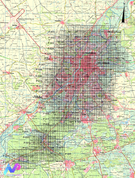
Aligning source images and producing the geo-referenced data, including deriving the map tiles, and delivering a confident and accurate dataset was Jose’s goal.
The somewhat irregular shape of the project required the use of Blue Marble’s Global Mapper to dice up the area into logical tile sections.
The project took 1 month of GCP measurement, 2 days of marker placement, 5 days of processing, 3 days of quality assurance and checking, and 1 day to produce the tiled outputs.
The final results are available as a tiled map service provided by the city council:
If you wish to browse the map and tiles then just click the map above, or here for a direct link.
Client Endorsement
City mapping services staff and users accessing the above portal have closely scrutinized the map for several months.
As a result, The city highly appreciates the excellent quality of the final ortho photo. Particularly noted are the remarks about compliance with the technical clauses of the contract. This coverage spans the entire city.
The City thinks Jose’s efforts are significant and important enough to warrant a certificate of execution. These certificates have become valuable as they help demonstrate the reliability of companies providing services to the public sector and go beyond any personal endorsement or simple advertising method.
The certificate is in Spanish, but is available here:
Undoubtedly, I can honestly say I am very proud and humbled to have Jose as our technical director. Given that Jose’s City Mapping is an impressive addition to Accupixel’s portfolio.
Bien hecho amigo mío, deberías estar orgulloso de tu logro.
Furthermore, if you have a mapping application and wish to discuss the project, approach, or workflow, please contact us. In fact, we will be happy to discuss your requirements.
In short, consider taking our online training courses to enhance your 3D mapping skills. Because you can improve your 3D outputs today! Moreover, much of the content derives from Jose’s knowledge and skills with photogrammetry. We cover Zephyr and Metashape to a very deep level.
Therefore, if you have already gathered the source data…and things are not working…we can help….just get in touch.
1 thought on “City Mapping Client Endorsement”