Its fair to say the US National Parks Service are a heavy user of underwater photogrammetry.
The depth and breath of the submerged natural, historic and cultural subjects covered by the Parks is truly stunning. Areas range from Alaska in the north via the fresh water Great Lakes in the midwest to shallow tropical seas and coral reefs of Florida in the south.
The Parks Service recognises underwater photogrammetry is a powerful tool to take the park resources into the digital space and extend their engagement beyond those who can dive.

The team is also involved in projects beyond the Parks, including programs to search for missing in action (MIA) service men. Deputy Chief AV Production Specialist Brett Seymour has just returned from having spent time documenting an amazing and unique graveyard of submerged Second World War era aircraft at Kwajalein Atoll in the Western Pacific.
Brett explains:
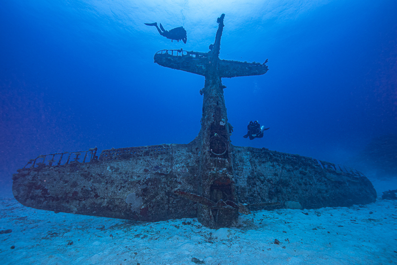
At the conclusion of a US Department of Defense survey in Kwajalein Atoll, the team from the National Park Service Submerged Resources Center and the Air Sea Heritage Foundation steamed to the northern part of the atoll for two days of documenting dozens of submerged aircraft near Roi-Namur with assistance from the Kwajalein MIA Project. This airplane graveyard, as well as other WWII aircraft in Kwajalein lagoon, represent the most comprehensive underwater collection of WWII aviation technology in the world. SBD Dauntlesses, B-25s, an Avenger, a Corsair, Jakes, PBM Mariners, a PB2Y Coronado, and more. The images and 3D models were produced in partnership with Pacific Historic Parks (PHP) to develop educational materials about WWII aviation from an underwater perspective.
Brett Seymour – National Parks Service
3DF Zephyr
As a result, the National Parks Service are a long standing AccuPixel client and Brett expressed an interest in trialling 3DF Zephyr on some of the aircraft datasets. We sent a trial license for Brett to run Zephyr, to see how the software would handle the often large volumes of underwater images the NPS work with.
The results speak for themselves.
Firstly, a Vought Corsair following initial camera alignment:
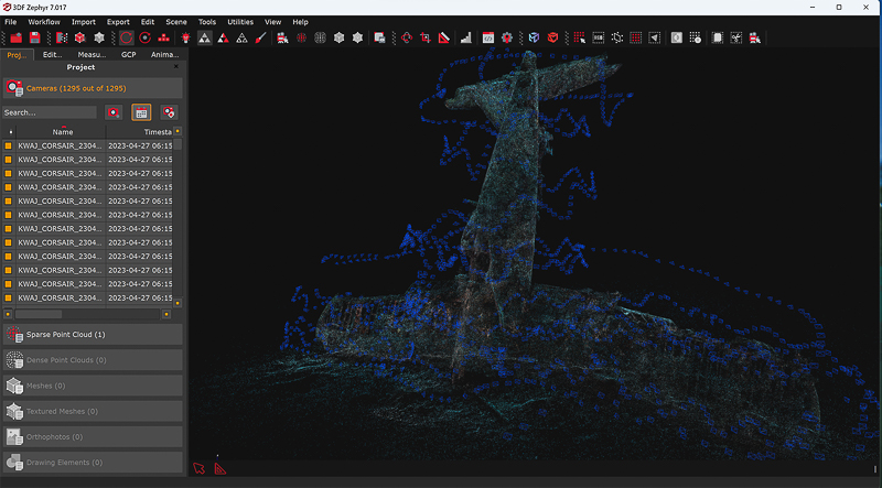
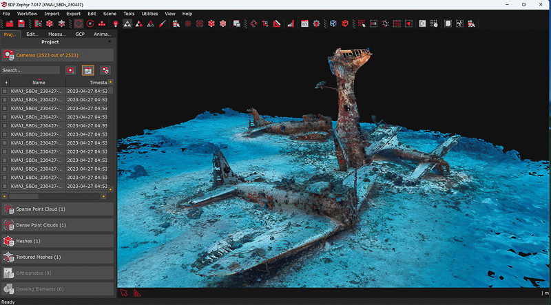
The same aircraft now shown with its mesh:

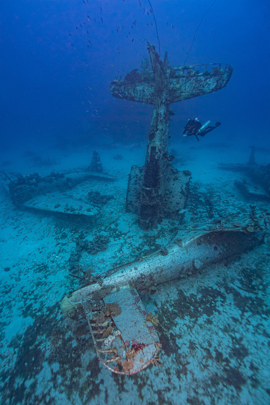
In fact, one of the larger sites has the remains of four aircraft which Brett has captured and processed in Zephyr:

As a result, It’s fair to say Brett has been quietly impressed with Zephyr. Because of Its ability to handle underwater subjects, such as aircraft with thin sections where detail is critical:
I’ve spent two weeks running several small (3-5k image) data sets with Zephyr and I’m very impressed. The backend mesh and dense cloud are much cleaner than our current workflow – with the added benefit of faster render times. Initially, I was not a fan of the “Wizard” workflow, but the software seems innovative enough to provide the highest quality possible with a basic user interface – even in the complex underwater environment. This is a definite benefit. There is no doubt that the high detail models are cleaner and the output is a higher quality. Very promising. We will be adding Zephyr into our underwater photogrammetry workflow moving forward.
Brett Seymour – National Parks Service
Also, You can check out the 3D model of the Vought Corsair here on the Construkted website:
Summary of photogrammetry and underwater parks service
In summary, the potential for photogrammetry to extend engagement and allow people to interact with, learn from and simply appreciate submerged cultural history is growing. However, most people won’t have the privilege to visit such a remote site, but the 3D model allows anyone to study and learn.
To clarify, education knows no limits and 3D is the tool to trigger questions. What are the aircraft types? Why are they in a remote lagoon? Who were the pilots? What events led to their loss?
We feel delighted that 3DF Zephyr will contribute to producing the outputs and starting the journey of discovery.
Lastly, do please use the contact us page if you wish to consider a trial of Zephyr. You can also discover more about our online training materials.
When I was in Kwajalein in the 1990s, Roi Namur diving was limited to personnel working for the US government. We were able to dive the Prinz Eugen (damaged in the atomic bomb tests at Bikini), and the Parking Lot, a dump of obsoleted WWII vehicles near shore from Ebeye.
Roi Namur was a faraway dream at the time